
|
|||
|
Colorado Fall Color Drives For a number of years, Darren Kilgore had the best online guide to fall color drives in Colorado with the best information on where to go and when to arrive for the best color. That guide is no longer online where it used to be posted. Fortunately, the page was archived for a number of years at the Internet Archive (Wayback Machine). A few years ago in preparation for a photography trip to Colorado I saved the whole page to my laptop so I could refer to it when I was up in the Colorado Rockies with no access to the internet. As an educational service to photographers, I am reproducing the page here as it appeared at the Internet Archive January 12, 2012
(and dated September 28, 2011). No commercial use is intended. All of the beautiful photographs below are by Darren Kilgore. Most of the links in the article will not work. I have kept the links "as is" in case they are
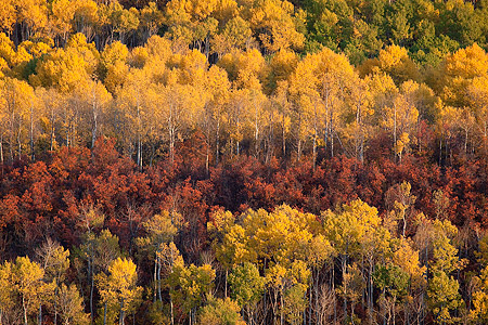
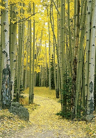
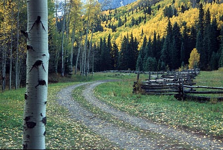
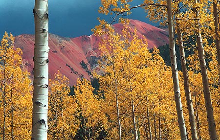
reactivated. If you are going to Colorado to photograph aspen, I would suggest you save this page to your laptop for your own personal use so you can refer to it when you don't have internet access. All photographs and text below are copyrighted © 2003-2011 by Darren Kilgore. A large map of Darren Kilgore's Colorado Fall Color Drives *** *** *** Welcome to the premier online resource for Colorado fall colors! Colorado is well known for its great palette of colors in the fall and has many great spots for viewing the aspens. I have detailed my favorite routes here which are the best of the best in the state. Please keep in mind, too, that spring is very awesome as well with the fluorescent lime green leaves. The week prior to Memorial Day through June 10 are great for those wonderful spring greens. Why am I confident this is the best site for Colorado fall color information? Well, there are many official state sites from the various media outlets that briefly describe a multitude of routes, but you'll rarely find any pictures. And then if you do, they're so small or not the greatest quality, so you're only left with taking the authors' word and you're left to your own interpretation, especially if they only give you a one-sentence description to go on. With my page, my pictures help reinforce my descriptions (well, hopefully!), and I'm sure most of you are the visual type. In addition, some of the usual routes they list are most certainly less than stellar, and if you're coming from out of state you don't need to be wasting your time trying to find the gold rush if you could be spending it in a real hot spot. In addition, as far as I know, I am the only one who provides accurate peak date information for the forests that I list, let alone any peak date information. If you're planning to travel from out of state, you will be at a loss if you're trying to go by any other site. All the information for a well-timed Colorado fall trip is located right here for you. Finally, I am easily accessible being only an email away if you have further questions for your trip should you need further input. This page is routinely evolving and being updated throughout the course of the year. Over the past number of years, it has proven to be one of my most popular pages on the site, and it is the most popular during the fall season, by far, so I'm always looking for ways to improve it, even if it's changing a word here or there. Yes, additional drives or locations are always considered. If I believe them to be worthy, they'll eventually find a place here, too. When To Go Peak fall color in the main aspen forests throughout the state ranges anywhere from September 20 to October 10, with September 27th usually being a good target date for the vast majority of the state to start a trip, and in general, I would say October 1 is the central peak date. You might come across sites indicating that trees in the northern part of the state will turn earlier than those in the southern parts. I have come to the conclusion that there is no correlation between north to south; I am under the firm belief they turn according to their elevation or respective latitude; and because aspens are found at the same elevation or proportionate latitude, they end up all changing right around the same time from the Canadian Rockies to Idaho and the Tetons, to Utah, Colorado, and New Mexico. The foliage maps out there that give the north to south thing as a general guideline, I believe is theory, and the people who put those together have never been out to see the trees first-hand between years, or get reliable reports. Many think the trees' color and their color-changing timing is related to how wet or dry, or whatever else type of weather phenomenon has happened. I can give an absolute guarantee that is not the case. The trees virtually turn the same time every year, give or take about three days, with every once in awhile being an odd year. To illustrate, in 2002, with Colorado's driest year on record, many scientists and others were predicting the aspens to turn a week or two ahead of normal because of the stress they had to endure throughout the year. It turns out that it was the latest I've seen the aspens peak since I've been going out to view them, which has been since 1997. The Telluride area, as of October 12, 2002, was just getting into peak colors. In contrast, 2001's peak date was around September 18 throughout much of the state. Those two years were the only two since I've been doing this that were out of line. So, there tends to be a lot of misinformation on the Web and in the local news outlets. Whatever the case, you'll always be able to find good fall color to shoot from about September 10 to the middle of October at least somewhere in the state; not necessarily whole forests, but rather more intimate scenes or individual trees. And, if you're on the early side on your trip, you can always count on the alpine tundra being a wonderful golden-brown with intermixed reds to give a great fall look. Some of the passes such as Cottonwood and Independence (out of Buena Vista and Leadville/Aspen, respectively) are great places with good views for that. Many wonder how the quality of the color display will be on a given year. My answer to that is that it is, without question, always the same brilliant-colored yellow that you're used to seeing up against that blue Colorado sky. One pet peeve of mine is seemingly every year one of the newspapers or newscasts will mention the aspen blight disease which causes brown or black leaves. Sure, there are always some trees affected by this, but they are so very few it is never worth mentioning. In the fall of 2006, all of the Colorado mountains received a big and very wet snowstorm from September 20 through the 22nd. The amount was anywhere from about 4-14", which was the most snow I've seen that early in the season. This initially caused many of the trees to go to a very dull mustard color immediately. However, the trees that weren't already just about to shed them rebounded within a week and went back to the traditional yellow. Now if that storm didn't kill 'em, nothing will! Edit: I must retract, to a degree, what I mentioned about leaf color. 2008 was the first year I saw a more widespread dull mustard color, though after fall 2009, I couldn't say for certain if it would was temporary or not. I saw the same thing in 2009, but even then, there was still limitless areas to enjoy the traditional yellow hue. According to scientists, this epidemic is called SAD, or sudden aspen decline, which is said to be related to the drought conditions in the early 2000s that is finally catching up and affecting the trees. I'll be curious to see if the spots in question rebound or not in the next few years. Until then, I'm not going to put 100% belief in the scientists based on their history of talking about the aspen tree. It is absolutely impossible to get good and reliable reports from the forest service and various chambers of commerce, whether speaking to them directly over the phone or viewing their Web sites as to what the leaves are doing and when to go; I speak from experience from my early years of going out. You would think they would be the best resources, but I guess they try to market their areas somehow. If you called them in mid-January they would tell you the leaves are at their peak and to get there NOW! So, the best places to get the information tend to be the various message boards from people who have just visited the areas and report back. The best places to keep track of the updates, without question, the Rocky Mountain Nature Photographers' site (I always add a fall report link from here) and 14ers.com (also always linked). In addition, our local CBS affiliate always puts up a viewer's gallery with dates the pictures were taken on. There are number of folks on the previously mentioned forums who have the same interests as myself and also do quite a bit of traveling, so the updates are current and fast. I typically do a pre-run during the weekends leading up to peak color, and link all of the vital updates and links on this page as well. Also, I recommend checking out my good friend, Brent Doerzman's, fall trips page. The links on there go into their respective picture pages. Dates are posted next to each image in his fall galleries. This greatly aids to get an idea of what the various forests look like on a given date. For other fall pictures in the areas I cover here and other areas of the state to see what is available and for further picture ideas, have a look at my various landscape galleries (namely, the Elks and San Juans). All of them are sorted by season, with fall being displayed first. The Places To See
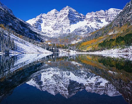
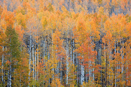
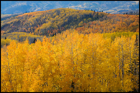
Maroon Bells, Maroon Creek Road
What Colorado fall color trip would be complete without a stop to our most fabled fall destination, the Maroon Bells, out of Aspen? Be sure to get here for sunrise and stay until late morning. Shooting sunrise can be tough here if the skies are clear since there is a high ridge at your back. A blended exposure may work best since the slope to the left of the lake will be solid black otherwise. Or, zoom in far enough that you aren't including any of the protruding hillsides, which would then be conducive to using a graduated filter. Your best hope for a wider shot is to have a big cloud bank overhead that can not only provide brilliant color at sunrise, but provide enough reflected light on the dark areas to give you a much better exposure. Be prepared to share the Maroon Lake shoreline with at least 50 other photographers on most mornings. On the picture above, as taken on a most memorable and magical Sunday morning of September 24th, 2006, there was quite possibly a record crowd of photographers here lined up before and at sunrise??"I would hazard a guess of around 130 people! It was the most I've seen here, by far, which many others have also attested. After shooting the Bells, on your way back out, there are a few pullouts that offer great vantage points of the area forests along Maroon Creek. Since you'll be in the Aspen area when you travel down Maroon Creek Road to the Bells, when you come back out, you might want to consider taking Castle Creek Road which heads down the next valley to the east, accessed from the same round-about intersection. There are some huge aspen forests towards the end of this road on the hills, and stopping in at the neat preserved ghost town of Ashcroft will be worth a couple of shutter clicks as well. If you have four-wheel drive, you can drive up to Taylor Pass and on into Taylor Park, though the trees will be at their best at the very start of this road. Peak color note: The aspen forest that lies within the classic Maroon Bells shot, like shown above, peaks earlier than most everything else in the state. The normal peak date is around September 26th, though I should note that the forest below them is always mixed every year, meaning that you'll see portions that are all gold and others will be dark and light green; or if you come later, half the trees will be gold and the other half stripped.
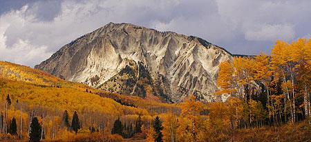
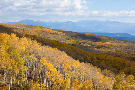
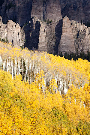
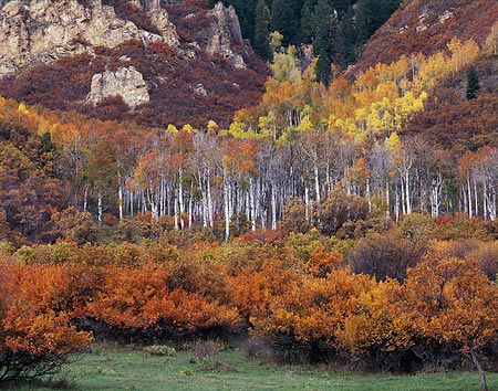
Kebler Pass
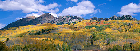
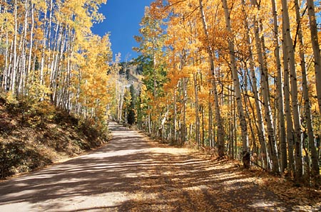
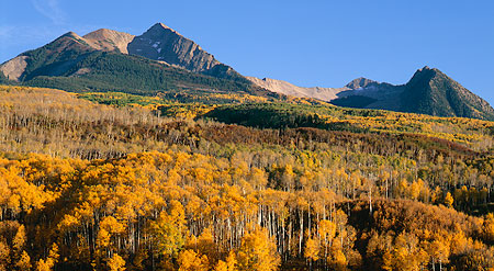
The first route that should be on the top of anyone's list is undoubtedly the Kebler Pass road which goes between Paonia Reservoir, near Somerset, to the west and Crested Butte to the east. This 30-mile stretch is the centerpiece of thelargest aspen forest in the world, which basically stretches between McClure Pass and Marble to the north, wraps around the Beckwith mountains, then into the West Elk Mountains to the south! Traveling from the west, you'll gently climb to some very impressive panoramas of the Raggeds to the north, the expansive view to the west and southwest, and the Beckwith mountains of the West Elks to the south (pictured above). A little further up the road, you get treated to very impressive views of Marcellina Mountain which lies on the border of the Raggeds Wilderness. Much of this road is filled with windy turns and is quite the experience if you have a sunroof (open, of course) and let some leaves fall next to your lap if there's a breeze. There just simply isn't a better place to experience aspen in the fall than this place. A number of grand scenics and limitless intimate forest shots can be taken here, not to mention literally hundreds of great dispersed camping opportunities. Lost Lake Slough makes for a nice sunrise shot between mile marker 15 and 16. It lies a couple miles back in along a forest road. About five miles west of the Kebler Pass summit, and between mile markers 19 and 20, is a turnoff to the Cliff Creek Trailhead which is just a few hundred feet to the west from the Horse Ranch Park driveway. You'll be sure to want to drive the real short distance up to the trailhead and stop here as it provides a magnificent overlook to one of the most colorful patches in the state (pictured above). You can always count on a couple of those clusters to be a brilliant red and orange. Be sure to use your longest telephoto lens to zoom in and isolate the colorful group along with a wider lens to take in the entire scene. This is best photographed at sunset, but mid-morning through the rest of the day really works great, too. Peak color note: Much of the entire length of the Kebler road is usually at peak around September 30, however the grand scene of the Beckwiths (first picture above) as seen between mile markers 10 through 13 will have a good mix of green yet in the forest at that time. It is usually all yellow around October 6th, though there will be a few smaller bare patches at that point.
Ohio Pass
Just below the 10,007' Kebler Pass summit to the east is the turnoff for the Ohio Pass road that heads south to Gunnison some 25 miles down the road. The 10,101' Ohio Pass is reached just one mile south along this road, then down just a bit further provides excellent views to the Castles, the appropriately named formations in the West Elk Wilderness, as pictured above. This upper stretch of Ohio Pass is filled with a massive aspen forest of its own and limitless photo ops. Kebler Pass and Ohio Pass are an unprecedented one-two combination. As you drive further down the road and out of national forest, you'll drive next to ranch land with more impressive views over to the Castles. Peak color note: Ohio Pass reaches peak color a couple days prior to Kebler Pass and is usually at peak around September 27th.
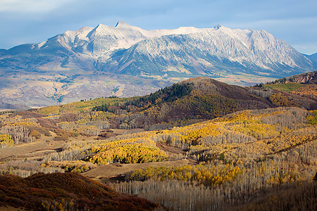
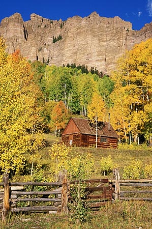
McClure Pass
?
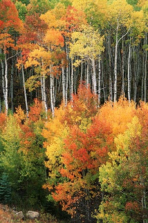
McClure Pass, in combination with Kebler and Ohio passes, would be my recommendation if you only had a single weekend for which to view fall colors. I could easily spend a week or two in this area alone. Starting near Redstone on the north side and ending approximately due west of Ragged Peak near the turnoff for Collbran lie a string of great photo ops. The divide itself is pretty low by Colorado standards, only topping out at 8,763', but it does provide some pretty spectacular views off to either side, including one of Mt. Sopris. The beautiful Chair Mountain and Ragged Peak dominate the skyline as you descend the southern side. You might even take a stab at composing a scene with the brilliant red scrub oak which is plentiful from here to Paonia. If you have time, drive the seven miles back in to Marble, and Crystal as well for that matter, providing you have a medium-clearance vehicle. There are plenty more aspen along that route awaiting you to arrive with your camera, namely the iconic Crystal Mill. The Crystal Mill is best photographed starting around 4:00. Shadows start to creep in the pool below at 4:30. If you plan to shoot later, plan to blend your images in post-processing, otherwise the contrast will generally be too great. If you don't have the means to drive to the mill, consider using the well-established services of Crystal River Jeep Tours based in Marble. While their arrival time might not be the most ideal, or their stop long (~20 minutes), it would definitely be worth checking out if you have the time. If you're looking to drive the road for the first time, you may want to see the preview I have here of the whole drive. Back on Highway 133, immediately south of the Marble turnoff on the west side of the highway has historically had a set of intense scarlet red trees, though to be honest, I'm not sure if they've turned red the past few years. You wouldn't miss them if they are. Then, just a short distance later to the south at the a large hairpin turn, you'll see one of former great aspen stands (pictured above) for which to photograph on the inside of the turn. As mentioned above in the picture caption, it hasn't looked like that in recent years. Tough to say at this point if it will ever return. Peak color note: This section has the wonderful green, red, orange and yellow mix around September 29th, as pictured above. If you wait another four to five days (October 4th), you'll have red and yellows only (peak color). Shooting from McClure's summit to the east at sunset will reward you with intense warm light on the aspen-covered hillside as it will from just a few miles down the road from where the best shots of Chair Mountain and Ragged Peak lie.
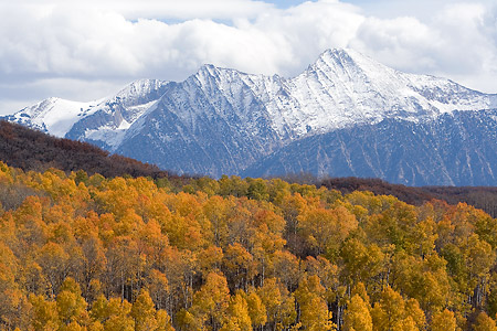
Grand Mesa
Peak color note: First week of October
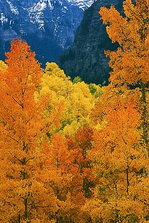
Capitol Creek
If you happen to be on your way over to McClure Pass as you head up to the road to Carbondale when departing Aspen, another awesome road heads out of Snowmass (not Snowmass Village) which eventually leads to the grand vista of one of Colorado's finest peaks, Capitol Peak (14,130'). Turn at the only light in Snowmass, then when you come to the "T" intersection, turn right on to Capitol Creek Road and you'll be on your way. There is a nice aspen forest that you'll drive through just prior to getting your first glimpses of Capitol through the trees from which you can shoot, but the real treat is of the grand Colorado scene when the view opens up to Capitol with the golden forest right near the Capitol Peak trailhead. The road is passenger car accessible to this point, but the road will be a bit rough. After the trailhead, AWD can occasionally be required to ascend the steeper short hill immediately following if it has deeper ruts. Other times, I am certain this can still be done in a passenger car. The above picture was taken on the steep hill immediately above the trailhead. Should you drive to the end of the road, there is another great vantage point of the peak, which I like even better along with more aspens to drive through.
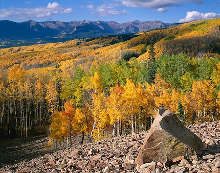
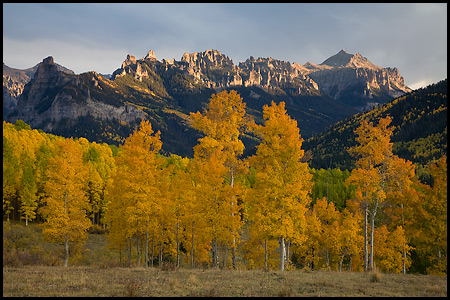
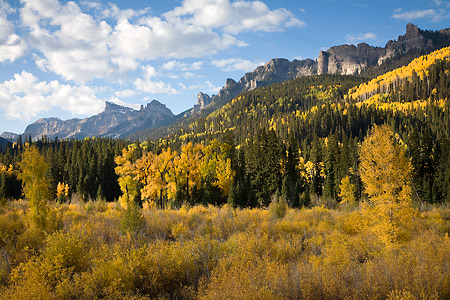
Owl Creek Pass
A little further up the road, there are three forks (East, Middle and West) of the Cimarron River which you can drive further to the south to near the Uncompahgre Wilderness, the first two being around six miles in length. There are manygreat camping possibilities along these spur roads. Just below the pass on the Ridgway side, the aspen really open up and line the road for a good distance. This is also the area of great views of Chimney Rock and Courthouse Mountain. Down the road a ways later as you start to make a somewhat steep descent, there are incredible views that open way up and let you view the entire Sneffels Range. And finally, as you're nearing Highway 550 and driving along some of the most beautiful ranch land anywhere, more possibilities of capturing the Sneffels Range await. Peak color note: The Silver Jack Reservoir side of the pass peaks about four days earlier than the Ridgway side. The trees in the immediate picture above peak earliest along the route, usually around September 29th.
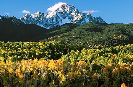
County Road 5, Ridgway
County Road 5 starts in Ridgway and travels back into an amazing aspen forest. This road is perhaps less traveled compared to County Road 7 to the west, but certainly no less impressive. Here you will find another classic shot of Mt. Sneffels towering above the hills and forests, as pictured above. You'll know the spot when you come to is as the road turns right out in a clearing. This spot is best at sunrise, but if there are clouds at sunset, it will be great then as well. Perhaps just as great as this view is the opportunity of unlimited possibilities of intimate forest scenes of aspen, as this road is lined with them. In fact, I have found more possibilities along this route using the road as a lead-in line through the trees than any other road that I've been on. It could be that I haven't paid too much attention on other roads, but it is so much more apparent along this one! This is a another true hot spot for fall photography.
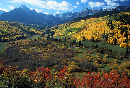
County Road 7 (East Dallas Creek), Ridgway
County Road 7, signed as Dallas Creek from Highway 62, is one of my favorite roads in the state since it leads to my favorite spot in the state??"the wonderfulvalley at the end at the foot of the majestic Mt. Sneffels, the crown jewel of the San Juans, and my favorite mountain. It's just so darn photogenic??"from any angle! The turnoff is about four miles west of Ridgway and heads south. It is about eight miles in length and the photo ops don't really start until the last two miles of it. The signature shot comes when you round the corner and the valley opens up before you around mile marker 7. If you've never been here before, you will certainly wonder why after your first visit! I should note that this isn't a fall drive, per se, rather it is a great fall hot spot. This is a popular area in the fallamongst photographers, so you may not be alone. Mid-morning and early evening is the ideal time to shoot here. The end of the road is about a mile further and stops at the Blue Lakes Trailhead. This area has a number of great camping spots that I've taken advantage on a number of occasions. For some additional spots worth checking out close by: Take County Road 9, signed as West Dallas Creek, a mile further to the west, which travels through Ralph Lauren's ranch land (and gate at the start that you will need open and close if found that way) and to Box Factory Park under Mears Peak at the end. Dallas Divide is about six miles up the highway from here for some more views of the mighty Sneffels Range, and is another iconic Colorado fall view. About a mile and a half to the west from the divide is a turnoff for Last Dollar Road. Take this road all the way down to Telluride for a lot more aspen and some awesome views of the San Miguels (Wilson Peak, etc.).
Million Dollar Highway (550)
From Ironton Park, which is the big, flat valley that you climb up to from Ouray, to the Purgatory resort, north of Durango, lies another stretch of high-volume aspen, with a grand forest being in Ironton Park. This also includes the highly recommended Lime Creek Road (unimproved dirt road) which bypasses Coal Bank Pass on either end. Both roads offer a multitude of scenes to point a camera at any time of year with some of the best mountain backdrops in the state, but the yellow hillsides really make the area come alive. Crystal Lake , on the northern end of Ironton Park, is a popular place to shoot looking south-southeast towards the red mountains. From here, the highway continues to the summit of Red Mountain Pass, then eventually drops into Silverton before climbing back up Molas and Coal Bank passes. Peak color note: This particular area turns about as early as anything in the state, usually reaching peak around September 25th.
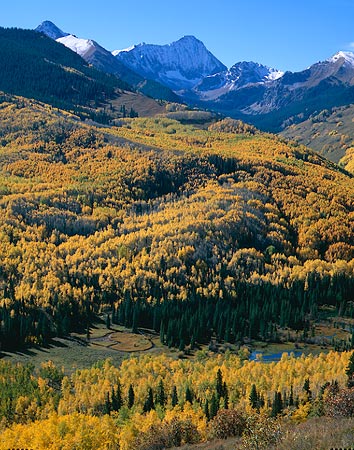
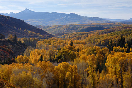
Flat Tops Scenic Byway
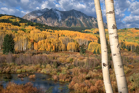
This 82-mile drive between Meeker and Yampa is home to a grand aspen forest that lies between Ripple Creek and Dunckley passes, and the majority of the route is lined with them. This byway easily rivals Kebler Pass for fall color viewing in terms of the number of aspens you'll see. It doesn't have as good of mountains as those found on Kebler, and you won't drive through the tunnels of aspens found on Kebler, but the Flat Tops of the White River Plateau provide for no lack of wonderful scenery. In addition, the area east of the small settlement of Buford sees little traffic, so you'll get to enjoy this landscape in relative solitude. From Meeker, the aspen get started around 16 miles in at, you guessed it, mile marker 16. One of the great stands along this road is at mile marker 23 on the south side. From here on out, you can choose any number of aspen scenes to shoot. In addition, there are multiple forest roads that head north and south of the main route, most of the ones on the north side requiring high-clearance and 4WD would be preferred for engine braking on the steep descents. This whole area is covered by great aspen forests that you can't see from the main road. Once in the White River National Forest a short while later, you'll soon come to the first campground along the way??"North Fork. From the North Fork Campground, it's about seven miles to the turnoff for the beautiful Trappers Lake. Be sure to take the ten-mile spur back to the lake if you've never been before. The lake sits in the Flat Tops Wilderness, so from the parking lot, it's a quick five-minute walk up the hill to get to the lake for the classic Colorado scene. The lake sits north-south, but I prefer to photograph in late afternoon. If you do plan for a sunrise or sunset shot from here, your best chance of a reflection of the main feature of the officially unnamed Amphitheatre Peak is from Anderson lake, which is a much smaller isolated lake and a quick ten-minute walk from the Wall Lake trailhead. Back on the main track, the road starts to ascend the 10,343-foot Ripple Creek Pass immediately after the Trappers Lake turnoff. A couple miles later after along the descent, you'll pass by Vaughn Lake. It's not too picturesque this time of year, but the hillside above it is a wonderful vibrant green in the springtime. Several miles down the road, you'll come to a small settlement and a junction with County Road 19 which lies in the heart of the biggest aspen forest along the byway. CR 19 heads north and parallels the East Fork of the Williams Fork River which leads towards Pagoda. I would definitely recommend at least driving the southern half, or about five miles of this road. Cottonwoods line the river down below and aspen cover the opposite, low hillside to the west. It's nice in mid-morning with front light, then in the late afternoon with backlight. Continuing past the junction with CR 29, the road starts ascending up 9,763-foot Dunckley Pass. From the top, you gain expansive views of the surrounding forest below along with that of the White River Plateau, including Pyramid Peak. Photographing from the pass works best at sunset. Descending Dunckley Pass to the east is gradual and eventually the aspen start to fiddle out where ranch land takes over. Peak color note: Usually around 10/1
Buffalo Pass
Buffalo Pass is accessed out of Steamboat Springs in the northwest part of the state. I struggled a bit with adding this to the mix the last couple of years, not because of the great aspens found here, but mainly due to the relative lack of them (I'll probably hear it from the locals now!), though that's probably not a fair statement at all. I don't think I viewed it as a fall color drive initially, but rather a fall color spot. However, that didn't stop me from putting a couple other similar items on this page. In addition, I've only visited here one one fall occasion, sadly, so I didn't, and still don't, feel like I could speak authoritatively on it. However, after being coaxed from a recent email, I thought about it again. If nothing else, this will give you another option in the northern part of the state along with the Flat Tops should that be where your travels take you. As I mentioned, I've only been here once in the fall, which was 2008. I had been shooting in the San Juans and just got the sudden urge to try something different and headed north for the last couple days of my trip. I'm really glad I did because I came home with a number of images I really like. I was also very pleasantly surprised with the darker oranges and a few red trees, though I don't know if that is the norm or not. Before you get to the main forest overlooks as pictured above, there are some nice aspens that line the road early on, though the road isn't wide enough to allow comfortably pulling over to photograph them, so I felt the main forest section was really the only good place to bring out the camera. Thankfully, the view is nice and the trees allow for a number of compositions. I would definitely say it is a can't-miss option if you're in this part of the state, but if not, there are enough areas to hold your attention further south. Truth be told, the Steamboat area has always been a favorite area of my family going way back to my very early years. We took numerous camping trips to Steamboat and Pearl lakes and I have many fond memories. The topography is not dominating for the most part, but rather soothing rolling hills. The exception is the main crest of the Park Range around Mt. Zirkel. Buffalo Pass lies on it's tame southern portion. If you find additional time to spend up here, there are more nice forests around Steamboat Lake and the settlement of Columbine a bit further north. There is a vast network of forest roads here that are waiting to be explored. Peak color note: As mentioned above, I've only been here once, so I hesitate to put much here! If I were planning a trip, I would aim for 10/1 to 10/3. Front Range Look at all these pictures! You're pretty much on your own with this one! I'm afraid I'll be of little help, but I'll do my best. Even though I live at the base of Colorado's Front Range (stretches from the Wyoming border to Colorado Springs), the problem is so does 4/5 of our state's population, so you might begin to see why most of my travels are further to the west. Combine that with generally round and tame mountains with a few exceptions. In addition, the aspen forests in this region pale in size to those found further west, though that is certainly not to say that you wouldn't enjoy many of views or come away with some top-notch pictures. Since I do get frequent inquiries about trip suggestions closer to Denver, I queried local photographers in 2008 to see what they'd suggest. The following is a summary of some day trip options: As a northerly option, drive the Peak to Peak Scenic and Historic Byway, which was Colorado's first and goes from Blackhawk to the south, via I-70, to Estes Park to the north. To the west of Denver, take Guanella Pass between Georgetown to the north and Grant to the south, which has aspens at the lower elevations at either end. Combine Guanella with Kenosha Pass, just east of Jefferson along Highway 285. Kenosha is one I didn't need help for as it has the largest aspen forest closest to Denver and half of my travels see me exit Denver this way. I am an expert drive-by shooter along here, but have never actually stopped in the fall. I'll work on finding a snapshot, but in the interim Google will be your friend. Southerly options include the southern portion of Rampart Range Road out of Woodland Park that includes some of the best views of Pikes Peak. Consider continuing south to Cripple Creek and take Phantom Canyon Road (part of the Gold Belt Tour Scenic Scenic and Historic Byway) south to Highway 50. Search for Gold Camp Road and take that back to Colorado Springs. Peak color note: Plan for 9/27-10/5. I am unable to be more specific. *** *** *** Posted September 28, 2011 |
|
[Home] [About] [Photos] [Learn] [Blog] [Portraits.JimDoty.com] [Contact] |
|
Copyright © Jim Doty, Jr. All rights reserved. |
|
|
|
||||||||||||||||||||||||


